RAJGIR
| Location |
: |
Lat. 25° 02’ N ; Long. 850 26’ E |
| District |
: |
Nalanda |
| State |
: |
Bihar |
| Excavation years |
: |
1999-2000 |
| Director of Excavations |
: |
Muhammad K.K. |
| Assisted by |
: |
D.K.Ambastha, D.K.Singh, N.K.Sinha & J.K.Tiwari, |
Rajgir the capital of ancient Magadha Kingdom, is referred as Vasumati (in Ramayana), Brahadrathapura, Girivraja (in Mahabharata) and Kushagrapura (by Hiun-T-Sang), is situated about 100 kms. south-east of Patna in Nalanda district on Bihar-Sharif-Gaya highway. It is also connected with a loop line of railway from Bakhtiyarpur Junction. Indian Railway submitted a proposal and a survey map to extension of the said railway line up to Gaya junction. Archaeological Survey of India conducted an exploration of the proposed area and it was noticed that several ancient relics will go under wheels of Indian Railway if proposed extension line has been approved.
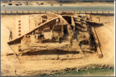
In this exploration, 7 mts. high and about 40 mts. at the base a mound has been noticed just east of the highway and about 5 km south of hot water spring, popularly known as Brahmkund and 100 mts. north of southern cyclopean wall.
This mound has taken up for excavation to establish culture sequence of the mound and to know the architectural pattern of the structures. The excavation has brought to light remains of a brick stupa constructed in terrace form. The lower terrace is measured 2925 mts. The height of this terrace is 1.96 mts with 28 courses of bricks. The buttress walls having dimensions of 9026 cm with 2 to 13 courses of bricks are provided at irregular intervals of 1.95 mts to 3 mts.
Above the lower terrace the remains of second terrace has been exposed. The southern side of the terrace is provided with 5 cm thick lime-concrete plaster.
The upper terrace is formed by the construction of brick chambers, filled with stone rubbles and earth. The measurement of these brick chamber varies from 3.11, 3.251.5, 4.73.7mts, 4.72.4 mts.
An apsidal structure was also exposed in western side over the remains of second terrace. The size of this apsidal structure is 132.4 mts. and similar to those found in Jivakamravana..
It seems that the all around the stupa, a brick paved circumbulatory passage was also provided the remains of which was found in the limited area of 7.10x1.5 mts attached to the buttress wall in the south east corner.
The bricks used for the construction of this whole structure measures 52x25x7 and 42x27x6 cms.
The pottery recovered during the excavation were Red ware, Grey ware, NBPW and Kaolin ware.
The presence of N.B.P.W. and use of bigger size bricks indicates that stupa may be assigned to Mauryan or pre-Mauryan period.
|